Zagros
| Zagros | |
|---|---|
 Zagros | |
| Nejvyšší bod | 4 548 m n. m. (Zard Kuh) |
| Nadřazená jednotka | Alpsko-himálajský systém |
| Sousední jednotky | Kuhrud, Elborz |
| Světadíl | Asie |
| Stát | |
| Horniny | prachovec, vápenec |
| Povodí | Tigris |
| Souřadnice | 33°40′ s. š., 47° v. d. |
| Některá data mohou pocházet z datové položky. | |

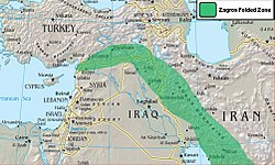
Zagros (kurdsky: زنجیره چیاکانی زاگروس ; arabsky زاغروس; turecky Zagros Dağları) je rozsáhlé pohoří v západní Asii. Táhne se v délce 1 500 km ze západního Íránu a severního Iráku (jižního Kurdistánu) podél hranic obou zemí až k severnímu pobřeží Perského zálivu. Má šířku 150 až 300 km. Jeho nejvýchodnější část zasahuje až k Hormuzskému průlivu. Nejvyššími vrcholy pohoří jsou Zard Kuh (4 548 m) a Dena (4 359 m). Zagros je největším pohořím Íránu.
Charakteristika
Hlavní část pohoří se skládá z řady paralelních hřbetů podobné výšky. Obvyklá výška hor se pohybuje mezi 2 500 až 3 000 m. Nejvyšší části pohoří se nachází ve střední části Zagrosu, řada hor zde převyšuje 4 000 m.
Geologie
Pohoří bylo vyvrásněno v období od svrchní křídy do počátku třetihor. Během tohoto období se vytvořila monumentální série paralelních vrás, z tohoto důvodu je také někdy pohoří nazýváno "vrásový Zagros".[1] Zagros je tvořen sedimentárními horninami, především vápencem.
Obyvatelstvo
Většina Zagrosu je poměrně řídce osídlena. Města a obce vznikaly především tam, kde to umožňovaly přírodní podmínky. Největším městem v oblasti je jedno z center perské kultury Šíráz.
Reference
Externí odkazy
 Obrázky, zvuky či videa k tématu Zagros na Wikimedia Commons
Média použitá na této stránce
Flag of Iran. The tricolor flag was introduced in 1906, but after the Islamic Revolution of 1979 the Arabic words 'Allahu akbar' ('God is great'), written in the Kufic script of the Qur'an and repeated 22 times, were added to the red and green strips where they border the white central strip and in the middle is the emblem of Iran (which is a stylized Persian alphabet of the Arabic word Allah ("God")).
The official ISIRI standard (translation at FotW) gives two slightly different methods of construction for the flag: a compass-and-straightedge construction used for File:Flag of Iran (official).svg, and a "simplified" construction sheet with rational numbers used for this file.
Zagros Mountains, Iran. Photo center point: 28.0° N, 54.0° E (near Banaruyeh). NASA Space Shuttle photo STS047-151-35.JPG. One of the most beautifully folded mountain ranges in the world, the southern Zagros Mountains of western Iran can be seen in this south-southwest looking low oblique view. Pushed up by the collision of crustal plates, the Zagros Mountains were buckled into high folds, or anticlines, and depressions, or synclines. Extending from northwest to southeast is a broad zone of long parallel lines of enormous hogback ridges and deep intervening valleys (right center to upper center of the image). There are numerous salt marshes in many of the valleys, such as Lake Bakhtegan, visible in the lower left portion of the image. Iran's major oil fields lie along the western foothills, where salt domes have trapped oil. The Persian Gulf is visible in the upper right portion of the image.


