Zandžán (město)
| Zandžán شهر زنجان | |
|---|---|
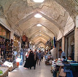
 Trh v Zandžánu | |
| Poloha | |
| Souřadnice | 36°40′ s. š., 48°29′ v. d. |
| Nadmořská výška | 1 638 m n. m. |
| Časové pásmo | UTC+3:30 |
| Stát | |
| provincie | Zandžán |
| Rozloha a obyvatelstvo | |
| Počet obyvatel | 430 871 (2016)[1] |
| Správa | |
| Starosta | Náser Musauví |
| Oficiální web | www |
| Telefonní předvolba | 0241 |
| Některá data mohou pocházet z datové položky. | |
Zandžán (persky شهر زنجان) je město v severozápadním Íránu a hlavní město provincie Zandžán. Město leží 298 km severozápadně od Teheránu na silnici z Tabrízu do Turecka, přibližně 125 km od Kaspického moře. Ve městě žije přibližně 431 tisíc[1] obyvatel.
Historie
Město Zandžán bylo založeno zakladatelem Sasánovské říše Ardašírem Pápakanem tehdy bylo známé pod jménem Šahín.
Reference
- ↑ a b جمعیت به تفکیک تقسیمات کشوری. Dostupné online. [cit. 2023-10-29]
Externí odkazy
 Obrázky, zvuky či videa k tématu Zandžán na Wikimedia Commons
Média použitá na této stránce
Flag of Iran. The tricolor flag was introduced in 1906, but after the Islamic Revolution of 1979 the Arabic words 'Allahu akbar' ('God is great'), written in the Kufic script of the Qur'an and repeated 22 times, were added to the red and green strips where they border the white central strip and in the middle is the emblem of Iran (which is a stylized Persian alphabet of the Arabic word Allah ("God")).
The official ISIRI standard (translation at FotW) gives two slightly different methods of construction for the flag: a compass-and-straightedge construction used for File:Flag of Iran (official).svg, and a "simplified" construction sheet with rational numbers used for this file.
Autor: Uwe Dedering, Licence: CC BY-SA 3.0
Location map of Iran.
Equirectangular projection. Stretched by 118.0%. Geographic limits of the map:
* N: 40.0° N
* S: 24.5° N
* W: 43.5° E
* E: 64.0° E
Made with Natural Earth. Free vector and raster map data @ naturalearthdata.com.


