Zanzan
| Zanzan | |
|---|---|
 | |
| Geografie | |
| Hlavní město | Bondoukou |
| Souřadnice | 8°30′ s. š., 3°15′ z. d. |
| Rozloha | 38,1 km² |
| Správa regionu | |
| Nadřazený celek | |
| Vznik | 1997 |
| Některá data mohou pocházet z datové položky. | |
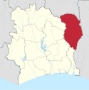
Zanzan je území na severovýchodě Pobřeží slonoviny. Jeho rozloha činí 38 000 km², v roce 2014 zde žilo 934 352 obyvatel.[1] Hlavním městem regionu je Bondoukou.
Až do roku 2011 byl jedním z 19 regionů, ze kterých sestával stát Pobřeží slonoviny. V roce 2011 proběhla reorganizace územně-správního členění státu a Zanzan se stal jedním z 14 distriktů. Sám je dále dělen do 2 regionů, ty pak do 9 departementů.
Reference
- ↑ Resultats Globaux [online]. Statistický úřad Pobřeží slonoviny [cit. 2015-12-28]. Dostupné online. (francouzsky)
Média použitá na této stránce
Flag of the Ivory Coast, written by Jon Harald Søby, modified by Zscout370. The colors match to what is reported at http://fotw.vexillum.com/flags/ci.html.
Autor: Prez001, Licence: CC BY-SA 3.0
Another variant of the Coat of Arms of Côte d'Ivoire seen in use here: http://www.gouv.ci/Main.php
This version has very stylized trees, and the gold is much darker. Also the gold doesn't extend to the rays of the sun.
I think there are lots of versions going around that is concurrently being used officially, mostly based on which version is readily available at the time an image of the coat of arms is needed.(c) Karte: NordNordWest, Lizenz: Creative Commons by-sa-3.0 de
Distrikt Zanzan in der Elfenbeinküste


