Zeměpisný pól

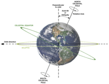
Zeměpisný pól, také geografický pól, je jeden ze dvou bodů na povrchu rotující planety nebo jiného rotujícího tělesa, kudy prochází pomyslná osa rotace. Poloha geografického pólu se může z důvodů nepravidelnosti otáčení planety v čase mírně měnit. Pozice zemských pólů se cyklicky mění v rozsahu několika metrů. Tento pohyb nelze zaměňovat s precesí.
Na Zemi existují dva póly: severní a jižní. Kartografie vyžaduje přesné a neměnné souřadnice. Proto je kartografický pól stanoven jako pevný bod, bez ohledu na momentální polohu geografického pólu. Kartografický pól je místo, ve kterém se protínají všechny poledníky.
Vedle geografického a kartografického pólu existuje také severní a jižní magnetický pól.
Související články
Externí odkazy
 Obrázky, zvuky či videa k tématu zeměpisný pól na Wikimedia Commons
Média použitá na této stránce
This visualization of a gravity model was created with data from NASA's Gravity Recovery and Climate Experiment (GRACE) and shows variations in Earth’s gravity field.
Gravity is determined by mass. Earth’s mass is not distributed equally, and it also changes over time.
The colors in this image represent the gravity anomalies measured by GRACE. One can define standard gravity as the value of gravity for a perfectly smooth 'idealized' Earth, and the gravity 'anomaly' is a measure of how actual gravity deviates from this standard. Red shows the areas where gravity is stronger than the smooth, standard value, and blue reveals areas where gravity is weaker. Red represents an acceleration of 5·10⁻⁴ m/s², blue represents -5·10⁻⁴ m/s², for a legend of the colors see File:Geoids sm.jpg.
GRACE is a collaborative endeavor involving the Center for Space Research at the University of Texas, Austin; NASA's Jet Propulsion Laboratory, Pasadena, Calif.; the German Space Agency and the German Research Center for Geosciences, Potsdam.
More information on the GRACE mission is online at http://www.csr.utexas.edu/grace/ and http://grace.jpl.nasa.gov/.(c) I, Dennis Nilsson, CC BY 3.0
Description of relations between Axial tilt (or Obliquity), rotation axis, plane of orbit, celestial equator and ecliptic.
Earth is shown as viewed from the Sun; the orbit direction is counter-clockwise (to the left).

