Zemětřesení v San Franciscu 1906
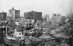
 Ruiny po zemětřesení v sousedství Post a Grant Avenue. Pohled severovýchodním směrem | |
| Datum | 18. dubna 1906 (13:12:21 UTC) |
|---|---|
| Síla | 7,1 - 8,3 Mw |
| Hloubka | asi 8 km |
| Epicentrum | 37°45′ s. š., 122°33′ z. d. |
| Zasažené země | |
| Oběti | přes 3 500 |
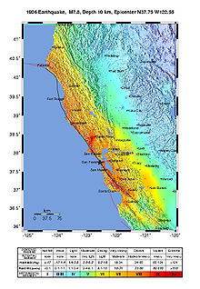
Zemětřesení v San Franciscu v roce 1906 bylo zemětřesení, které postihlo v 13:12:21 UTC (05:12:21 místního času) ve středu 18. dubna 1906[1] oblast Sanfranciského zálivu. Hypocentrum otřesu s magnitudou 7,1 Mw - 8,3 Mw se nacházelo západně od průlivu Zlatá brána (pravděpodobně na souřadnicích 37,75° s. š., 122,55° z. d.) v hloubce 8 km (±5 km).[2]
Hlavní epicentrum otřesů se nacházelo na pobřeží 3 km, blízko skal nazvaných Mussel Rock. Otřesy byly cítit až v Los Angeles a ve vnitrozemí až v centru Nevady. Zemětřesení a hlavně následný požár si vyžádaly přes 3 000 lidských životů[1] a je považováno za jednu z nejhorších živelních pohrom v historii Spojených států.
Zemětřesení

Ke katastrofě došlo téměř tři dekády před vznikem Richterovy Stupnice, nicméně nejčastější odhady hovoří o síle 7,9 Mw[1]. Jiné odhady přisuzují zemětřesní sílu od 7,7 Mw až po 8,3 Mw[3]. Podle zjištění publikovaných v časopise Journal of Geophysical Research došlo před i po zemětřesení k silným deformacím zemské kůry. Ruptura se šířila severojižně v celkové délce asi 476 km (296 mi)[4].
Silný předtřes udeřil 20 - 25 vteřin před hlavním otřesem, který trval asi 42 vteřin. Během desetiletí před zemětřesením z roku 1906 bylo zaznamenáno mnoho slabších otřesů - více než v kterékoli jiné době. Tyto otřesy byly dlouho považovány za předzvěst velké katastrofy, nicméně později se zjistilo, že měly silný sezonní charakter patrně způsobený překrytím zlomů v zálivech sedimenty uvolněnými při erozi způsobené hydraulickou těžbou používanou v pozdějších letech zlaté horečky[5].
Požáry
Požáry, které zachvátily město bezprostředně po otřesech, způsobily více škody než samotné zemětřesení a následné dotřesy[6]. Odhaduje se, že právě požáry mají na svědomí až 90% všech škod způsobených touto katastrofou[7]. Více než 30 požárů zničilo během tří dnů přibližně 25 000 budov ve 490 blocích. Většinu požárů způsobil plyn unikající z poškozeného potrubí, nicméně část zavinili hasiči, když pomocí dynamitu odstřelovali budovy ve snaze zabránit dalšímu šíření ohně. Požáry zuřily celkem čtyři dny a čtyři noci a způsobily škody přibližně ve výši 350 milionů tehdejších USD.
Fotografie San Francisca
George Lawrence
Slavné fotografie San Francisca po zemětřesení v roce 1906 pořídil George Lawrence velkoformátovým panoramatickým fotoaparátem a stabilizační plošiny, kterou sám navrhl.[8] Jednalo se o 160stupňovou panoramatickou fotografii pořízenou z výšky 600 metrů (pomocí draků), která byla vyvolána kontaktním otiskem z negativu o rozměrech 17 x 48 palců (43,18 x 122 cm). Fotoaparát vážil 22 kilogramů a používaly se v něm celuloidové desky. Lawrence prodával tyto snímky za 125 dolarů a celkem za prodané fotografie získal 15 000 dolarů. V roce 1908, tedy dva roky po události, nasnímal zrekonstruované San Francisco ze stejných pohledů.
O sto let později se tým fotografů okolo Rona Kleina z International Association of Panoramic Photographers pokusil zrekonstruovat Lawrencův snímek. Zhotovili přesnou repliku Lawrencovy panoramatické kamery - nefotografovali však z draka, ale z vrtulníku.[9]

.
Arnold Genthe

Dalším velkým fotografem, který zdokumentoval zkázu San Francisca, byl Arnold Genthe. Byl to místní fotograf, takže oproti Lawrencovi začal dokumentovat zničené a požáry zachvácené město bezprostředně po zemětřesení (a to navzdory tomu, že při katastrofě přišel o svůj ateliér).
Jeho fotografie focené z ulice či blízkých kopců, z nichž se zachovalo asi 180, ukazují zničené město zachvácené rozsáhlými požáry. Patrně nejslavnější z nich a zároveň nejslavnější Gentheho fotografií vůbec je fotografie Pohled dolů na Sacramento Street, focená z vrcholu Nob Hill.
Odkazy
Reference
- ↑ a b c Zemětřesení v San Franciscu v roce 1906 na stránkách USGS. earthquake.usgs.gov [online]. [cit. 2009-09-03]. Dostupné v archivu pořízeném dne 2009-05-10.
- ↑ Location of the Focal Region and Hypocenter of the California Earthquake of April 18, 1906
- ↑ THATCHER, Wayne. Strain accumulation and release mechanism of the 1906 San Francisco Earthquake. Journal of Geophysical Research (1896-1977). 1975, roč. 80, čís. 35, s. 4862–4872. Dostupné online [cit. 2021-05-01]. ISSN 2156-2202. DOI 10.1029/JB080i035p04862. (anglicky)
- ↑ USGS Earthquake Hazards Program. earthquake.usgs.gov [online]. [cit. 2021-05-01]. Dostupné online.
- ↑ WESTAWAY, R. Seasonal Seismicity of Northern California Before the Great 1906 Earthquake. pure and applied geophysics. 2002-01-01, roč. 159, čís. 1, s. 7–62. Dostupné online [cit. 2021-05-01]. ISSN 1420-9136. DOI 10.1007/PL00001268. (anglicky)
- ↑ The Learning Network. The New York Times. Dostupné online [cit. 2021-05-01]. ISSN 0362-4331. (anglicky)
- ↑ 100th Anniversary 1906 San Francisco Earthquake Conference. www.1906eqconf.org [online]. [cit. 2021-05-01]. Dostupné online.
- ↑ BAKER, Simon jazyk=anglicky. The Lawrence Captive Airship over San Francisco [online]. Dostupné online.
- ↑ Archivovaná kopie. www.ronkleinphotos.com [online]. [cit. 2010-09-08]. Dostupné v archivu pořízeném dne 2010-10-11.
Externí odkazy
 Obrázky, zvuky či videa k tématu Zemětřesení v San Franciscu 1906 na Wikimedia Commons
 - Před sto lety shořelo San Francisco na Aktuálně.cz
- Časová osa průběhu zemětřesení a záchranářských prací
- Zemětřesení v San Franciscu na Vitrual Museum of San Francisco
Média použitá na této stránce
Autor: Uwe Dedering, Licence: CC BY-SA 3.0
Location map of the USA (without Hawaii and Alaska).
EquiDistantConicProjection:
Central parallel:
* N: 37.0° N
Central meridian:
* E: 96.0° W
Standard parallels:
* 1: 32.0° N
* 2: 42.0° N
Made with Natural Earth. Free vector and raster map data @ naturalearthdata.com.
Formulas for x and y:
x = 50.0 + 124.03149777329222 * ((1.9694462586094064-({{{2}}}* pi / 180))
      * sin(0.6010514667026994 * ({{{3}}} + 96) * pi / 180))
y = 50.0 + 1.6155950752393982 * 124.03149777329222 * 0.02613325650382181
      - 1.6155950752393982  * 124.03149777329222 *
     (1.3236744353715044  - (1.9694462586094064-({{{2}}}* pi / 180))
      * cos(0.6010514667026994 * ({{{3}}} + 96) * pi / 180))
San Francisco lies in ruins on May 28, 1906, about six weeks after the 1906 San Francisco earthquake and fire. It was taken from a camera suspended on a kite, perhaps 1,000 feet above the city. It is one of the most well-known photographs of George R. Lawrence (see biography for more information about the technique used). The tower of the Ferry Building can be seen at the bay end of Market Street, which can be clearly seen all the way to the foothills of Twin Peaks. The water in the foreground is San Francisco Bay, with the Golden Gate to the right, rear. Note the absence of the Golden Gate Bridge and the San Francisco-Oakland Bay Bridge, which had yet to be constructed. Source information can be found on the description page of the original image. This is a version edited for the Featured Picture Candidates page.
San Francisco earthquake of 1906.
- Looking Down Sacramento St., 1906. [verso:] "San Francisco: April 18, 1906." From As I Remember by local photographer Arnold Genthe: This photograph shows "the results of the earth quake, the beginning of the fire and the attitude of the people." It was taken the morning of the first day of the fire. Shows Sacramento St. at Miles Place (now Miller Place) near Powell St.
- "I found that my hand cameras had been so damaged by the falling plaster as to be rendered useless. I went to Montgomery Street to the shop of George Kahn, my dealer, and asked him to lend me a camera. 'Take anything you want. This place is going to burn up anyway.' I selected the best small camera, a 3A Kodak Special. I stuffed my pockets with films and started out.... Of the pictures I had made during the fire, there are several, I believe, that will be of lasting interest.
- There is particularly the one scene that I recorded the morning of the first day of the fire [along Sacramento Street, looking toward the Bay] which shows, in a pictorially effective composition, the results of the earthquake, the beginning of the fire and the attitude of the people. On the right is a house, the front of which had collapsed into the street. The occupants are sitting on chairs calmly watching the approach of the fire. Groups of people are standing in the street, motionless, gazing at the clouds of smoke. When the fire crept up close, they would just move up a block. It is hard to believe that such a scene actually occurred in the way the photograph represents it.
- Several people upon seeing it have exclaimed, "Oh, is that a still from a Cecil De Mille picture?" To which the answer has been, "No. the director of this scene was the Lord himself." A few months ago an interview about my work--I had told the story of that fire picture--appeared in a New York paper with the headline, "His pictures posed by the Lord, says photographer.""
- -Arnold Genthe, "As I Remember" Reynal & Hitchcock : New York, 1936; Chapter 10: Earthquake and Fire
- "On 18 April 1906, the morning of the great San Francisco earthquake, Genthe, with his cameras and studio destroyed, borrowed a hand-held camera and photographed the destruction across the city. Of his over 180 surviving, sharp-focus photographs of San Francisco, probably his most famous image is "San Francisco, April 18th, 1906," which shows a view from Nob Hill, down Sacramento Street. Enormous clouds of smoke ominously approach, buildings' facades have collapsed from the quake, and residents stand and sit in the street, in a stupor, calming watching the approaching fire."
- - Mel Byars, N. Elizabeth Schlatter. "Genthe, Arnold"; American National Biography Online Feb. 2000.
Bull's eye graphic for use with earthquake location maps.
San Francisco Earthquake of 1906: Ruins in vicinity of Post and Grant Avenue. Looking northeast.


