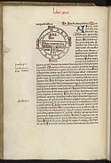
Diagrammatic T-O world map - 12th century
Autor:
Isidore of Seville
Shortlink:
Zdroj:
Formát:
608 x 767 Pixel (95263 Bytes)
Popis:
- T and O style mappa mundi (map of the known world) from the first printed version of Isidorus' Etymologiae (Kraus 13). The book was written in 623 and first printed in 1472 at Augsburg by one Günther Zainer (Guntherus Ziner), Isidor's sketch thus becoming the oldest printed map of the occident.
- Note: T-O-maps are typically displayed "East-up", show Jerusalem at the center and the paradise at the outmost East, balanced by the pillars of Hercules at the outmost West.
- Title of Book: Etymologies
- Author: Isidore, Saint, Bishop of Seville
- Production: 12th century
- Language: Latin
From The British Library; Record Number - c5933-06; Shelfmark - Royal 12 F. IV;
Page Folio Number - f.135v.
Licence:
Public domain
Credit:
Losslessly cropped from http://www.imagesonline.bl.uk/britishlibrary-store/Components/707/70737_2.jpg at [1]
Relevantní obrázky
Relevantní články
Isidor ze SevillyIsidor ze Sevilly byl encyklopedický učenec, biskup v Seville, poslední autor latinské patristiky a jeden z nejvlivnějších autorů raného středověku. Je uctíván jako světec. Papež Benedikt XIII. jej roku 1722 prohlásil za učitele církve. .. pokračovat ve čtení


