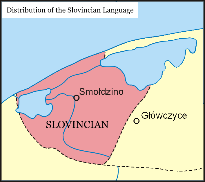
Distribution of the Slovincian language in the 20th century, in red
Autor:
Přisuzování:
Obrázek je označen jako „Vyžadováno uvedení zdroje“ (Attribution Required), ale nebyly uvedeny žádné informace o přiřazení. Při použití šablony MediaWiki pro licence CC-BY byl pravděpodobně parametr atribuce vynechán. Autoři zde mohou najít příklad pro správné použití šablon.
Shortlink:
Zdroj:
Formát:
707 x 627 Pixel (75057 Bytes)
Popis:
This map highlights the distribution of the Slovincian language during the 20th century. The map showcases the geographical areas where Slovincian was spoken, utilizing a vivid red color to emphasize its presence. Additionally, major cities in the region are marked, providing a helpful context for understanding the linguistic landscape. Dotted lines on the map delineate the extent of Kashubian dialects, offering further insights into the linguistic variations within the broader Slavic language family. This map serves as a valuable resource for researchers, linguists, and language enthusiasts interested in exploring the historical spread and significance of the Slovincian language in the 20th century.
Licence:
Credit:
Vlastní dílo
Sdílet obrázek:


Relevantní články
Severní slovinštinaSeverní slovinština (slovjīnsħi jązěk, slovjīnsħê gådąńê, słowińsczi jãzëk), výjimečně též slovinčtina je mrtvý jazyk z větve západoslovanských jazyků. Používali ji Pomořanští Slovinci. Považuje se velmi často za nářečí kašubštiny, pomořanštiny nebo polštiny. Vymřela s přesuny obyvatelstva po skončení 2. světové války. .. pokračovat ve čtení