Dunedin Panorama
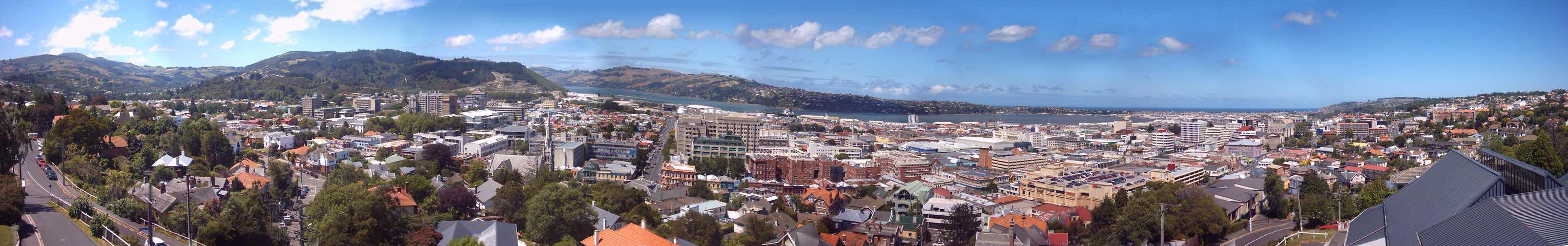
It's a large picture at 500K, but jpegs of house scenes (also aerial photos of buildings) seem to need a lot of space.
The road at the far left is Heriot Row, as is the road at the far right. The left of the picture looks up North East Valley. Moving right, university buildings, such as the microbiology and law buildings, can be seen.
The quarry close to Logan Park is noticeable, as is the spire of Knox Church on George Street. The hospital is across the road (Frederick Street) from the dentistry building with blue painted windows. Then there's the green and grey pharmacy building, followed by the red brick of the medical school.
East across the harbour we see the en:Otago Peninsula, sparsely dotted with houses. Back in the city malls, en:supermarkets and en:carparks stand out. Next are the commercial buildings. The Octagon is not visible.
The sea in the distance, past South Dunedin, is the en:Pacific Ocean.
Released under GFDL.
Will update this if I get better at using the stitching program.


Relevantní obrázky


.jpg)


Relevantní články
DunedinDunedin je druhé největší město na Jižním ostrově Nového Zélandu a centrum regionu Otago. Z geografických, historických a kulturních důvodů je pokládáno za jedno z pěti hlavních sídel země. Čtyři další nejdůležitější města Nového Zélandu jsou Auckland, Wellington, Christchurch a Hamilton. Do roku 2010, kdy byl po administrativní změně předstižen Aucklandem, byl Dunedin největším městem podle rozlohy. Před rokem 1900 mělo toto město i nejvíce obyvatel. K 30. červnu 2014 dosáhl počet obyvatel Dunedinu 124 600. .. pokračovat ve čtení