El Hierro Submarine Volcano Eruption - NASA Earth Observatory
To download the full resolution and other files go to: earthobservatory.nasa.gov/IOTD/view.php?id=77171&src=...
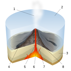
Four months after it began, the underwater volcanic eruption off El Hierro Island persists. This natural-color satellite image, collected on February 10, 2012, shows the site of the eruption, near the fishing village of La Restinga.
Bright aquamarine water indicates high concentrations of volcanic material. Immediately above the vent, a patch of brown water resembles a turbulent hot tub and indicates when and where the eruption is strongest. Video of the eruption shows the activity in more detail.
This image was acquired by the Advanced Land Imager (ALI) aboard the Earth Observing-1 (EO-1) satellite. The eruption is just off the southern coast of El Hierro, the youngest of the Canary Islands. El Hierro is about 460 kilometers (290 miles) west of Morocco and Western Sahara.
According to El Hierro Digital, measurements of the sea floor by the Instituto Oceanográfico Español found that the volcano’s summit is now only 120 meters (390 feet) beneath the ocean surface—10 meters (30 feet) higher than it was in mid-January. The height of the erupting cone is about 210 meters (690 feet) above the former ocean bottom, with a total volume over 145 million cubic meters (512 million cubic feet) of new material.
NASA Earth Observatory image by Jesse Allen and Robert Simmon, using EO-1 ALI data. Caption by Robert Simmon.
View more from this event at earthobservatory.nasa.gov/NaturalHazards/event.php?id=762...
The Earth Observatory's mission is to share with the public the images, stories, and discoveries about climate and the environment that emerge from NASA research, including its satellite missions, in-the-field research, and climate models.
Like us on Facebook
Follow us on Twitter
Add us to your circles on Google+Relevantní obrázky
Relevantní články
Podmořská sopkaPodmořská sopka je sopka nacházející se celou výškou pod hladinou moře nebo oceánu. Jedná se tedy o místo či prasklinu, kudy se z nitra Země dostává magma na povrch. Až na výjimky většina podmořských vulkánů leží na rozhraní tektonických desek. Odhaduje se, že středooceánské hřbety jsou zodpovědné za 75 % všeho magmatu, které se dostane na zemský povrch. Ačkoli se podmořské sopky soustředí zpravidla v hlubokých vodách, některé mají vrchol velice těsně pod hladinou, takže mohou během erupce vyvrhovat sopečný popel do atmosféry. .. pokračovat ve čtení


