Heavy Rains in Southern Japan
Autor:
Hal Pierce
Shortlink:
Zdroj:
Formát:
320 x 240 Pixel (8756759 Bytes)
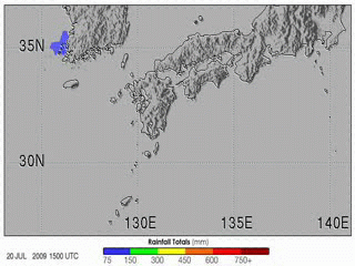
Popis:
The 2009 summer monsoon brought torrential rains to south western Japan in July. This animation shows rainfall estimates for southern Japan and the surrounding region from July 20–27. The most prominent feature is a large bull’s-eye of heavy rain centred over the northern part of Kyushu and the south western tip of Honshu. Rainfall totals exceeded 600 millimetres (shown in deep blue) at the centre of this rain area, with lesser amounts of up to 150 millimetres (shown in pale green) extending into central Japan. The heavy rains led to widespread flash flooding and numerous landslides. As of late July 2009, eight people were reported to have died as a result, with nine more still missing, according to news reports. Each year as the Earth’s orbit brings the Northern Hemisphere back under more direct sunlight, the Asian continent starts to heat up. Land surfaces have less heat capacity than surrounding oceans, and they heat up faster. This land-sea temperature difference causes the winds to shift; warm air rises over the continent, and moist air from over the oceans flows in to replace it. In East Asia, the boundary between the warm, humid air from the ocean to the south and the continental air to the north often becomes more or less stationary. This stationary front is known as the Baiu front in Japan and as the Mei-yu front in China. The location of the front migrates slowly northward over eastern China, Korea, Taiwan, and Japan over the course of spring and early summer, providing a focus for showers and rain, especially when waves of low pressure move along the front. Mei-yu means “plum rains” in Chinese, so called because the widespread rains often occur at the time when plums ripen, which is typically May and June. Baiu season in Japan typically runs from June through July.
Licence:
Public domain
Credit:
Sdílet obrázek:


Relevantní obrázky
.svg)


Relevantní články
Geografie JaponskaJaponsko je ostrovní stát, který se nachází na okraji kontinentálního šelfu u východního pobřeží Asie. Jeho přirozenou hranici tvoří moře, přičemž celková délka hranic je cca 30 000 km. Na východě a jihu je omýváno Tichým oceánem, na západě Východočínským a Japonským mořem a severní pobřeží se dotýká Ochotského moře. Od pevninské Jižní Koreje ho dělí Korejský průliv asi 180 km široký. Ostrovní stát zabírá plochu 377 801 km2 tvořenou 4 hlavními ostrovy, souostrovím Rjúkjú a více než 3 000 malými ostrůvky. .. pokračovat ve čtení