Jomann Imperium Periscum
Autor:
Shortlink:
Zdroj:
Formát:
1992 x 1700 Pixel (2287962 Bytes)
Popis:
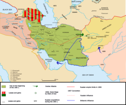
Map of Persia
Copperplate print on paper, colorized, 53 × 60.7 cm
Licence:
Public domain
Credit:
Relevantní obrázky
Relevantní články
Dějiny ÍránuDějiny Íránu sahají více než pět tisíc let do minulosti a zahrnují území, jež je mnohem rozsáhlejší nežli současná Íránská islámská republika, vzniklá v roce 1979. Je to dáno tím, že Peršané – kulturně i politicky dominantní etnikum Íránu – v různých dobách ovládali i teritorium dnešního Iráku, Turecka, Sýrie, Arménie, Gruzie, Ázerbájdžánu, Afghánistánu, Turkmenistánu a Pákistánu. .. pokračovat ve čtení


