Lake tanganyika
Formát:
5266 x 5266 Pixel (8806419 Bytes)
Popis:
This east-looking, high-oblique photograph features
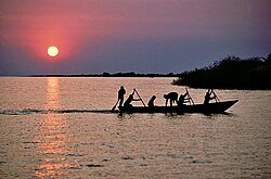
Lake Tanganyika—the second deepest freshwater lake in the world with a maximum depth of 4710 feet (1436 meters) and the longest lake in the world, stretching 410 miles (660 kilometers) north to south. Its width varies between 10 and 45 miles (16 and 72 kilometers). The lake, bordered on either side by steep slopes, fills a long narrow trough in the western arm of Africa's Great Rift Valley and supports a thriving fishing industry. The lake basin, a landform in which a block of the Earth's crust dropped down between blocks that rise on either side, began to form nearly 25 million years ago as part of the Great Rift Valley. On the lake's west shore is Tanganyika's sole outlet, the Lukuga River, which is a tributary of the Zaire River (northwest portion of photograph). The Zaire River flows westward and empties into the Atlantic Ocean. Other features in the photograph are shallow, silt-laden Lake Rukwa to the east of the lake and the extreme northern tip of Lake Nyasa near the southeast horizon.
Více informací o licenci na obrázek naleznete zde. Poslední aktualizace: Fri, 11 Aug 2023 18:09:25 GMT
Relevantní obrázky
Relevantní články
Tanganika (jezero)
Tanganika je jezero ve Východní Africe na hranicích Demokratické republiky Kongo, Tanzanie, Zambie a Burundi. Většina jeho rozlohy patří Demokratické republice Kongo (45 %) a Tanzanii (41 %). Nachází se mezi masivy hor na západní straně Velké příkopové propadliny. Jezero je nejhlubší v Africe, svou rozlohou druhé největší v Africe a obsahuje nejvíce vody ze všech afrických jezer. Má rozlohu 34 000 km². V severojižním směru měří zhruba 650 km a je 40 až 80 km široké. Dosahuje maximální hloubky 1470 m. Průměrná hloubka je 570 m. Rozloha povodí činí 244 500 km². Délka pobřeží činí 1828 km. Leží v nadmořské výšce 773 m.
.. pokračovat ve čtení


