Lane to Vindolanda on line of Roman Stanegate - geograph.org.uk - 407910
(c) Phil Champion, CC BY-SA 2.0
Autor:
Shortlink:
Zdroj:
Formát:
640 x 426 Pixel (149516 Bytes)
Popis:
Lane to Vindolanda on line of Roman Stanegate The roman road is buried beneath the modern road. The stump of stone on the left is the remains of a roman milestone marling the sixteenth roman mile west of Corbridge. It is recorded as being intact in 1725, some time after which the upper section of the milestone was broken off and split into two to provide gateposts. It was inscribed BONO REIPUBLICAE NATO, `To him who was born for the good of
the State', a compliment to the reigning emperor.
Licence:
Credit:
From geograph.org.uk
Relevantní obrázky
Relevantní články
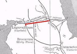
StanegateStanegate byla důležitá římská vojenská silnice postavená na území, které se později začalo nazývat severní Anglie. Silnice o délce 61 km spojovala dvě pevnosti: Corstopitum (Corbridge) u řeky Tyne na východě a pevnost Luguvalium (Carlisle) na silnici Dere Street a řece Eden na západě. Pevnosti mimo jiné střežily významné přechody přes tyto řeky. .. pokračovat ve čtení


