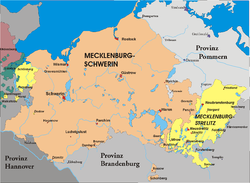
Lordship of Mecklenburg locator map (1250)
Přisuzování:
Obrázek je označen jako „Vyžadováno uvedení zdroje“ (Attribution Required), ale nebyly uvedeny žádné informace o přiřazení. Při použití šablony MediaWiki pro licence CC-BY byl pravděpodobně parametr atribuce vynechán. Autoři zde mohou najít příklad pro správné použití šablon.
Shortlink:
Zdroj:
Formát:
990 x 780 Pixel (3289078 Bytes)
Popis:
A map of the Lordship of Mecklenburg (German: Herrschaft Mecklenburg) (red) at the time of the Hohenstaufen Emperors (circa 1250).
The highlighted area shows the territories that would later become the Duchy of Mecklenburg (with the exception of Strelitz/Stargard, which were still part of the Margraviate of Brandenburg at this point in history).
Note that while it uses the same scheme as standard location/locator maps, this map technically does not conform to the standard, as it is not in equirectangular projection. Therefore grid lines for latitude and longitude are also included on the sub-map.
Licence:
Credit:
File: own work
Data: Droysens-26.jpg
Data: Droysens-26.jpg
Relevantní obrázky
Relevantní články
MeklenburskoMeklenbursko je historická země na severu Německa při pobřeží Baltského moře o rozloze asi 16 057 km². .. pokračovat ve čtení


