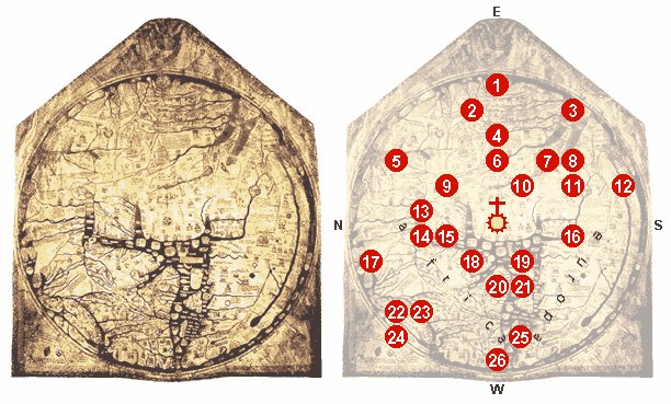
Mappa mundi Hereford 1300 explained
File:Hereford Mappa Mundi 1300.jpg, edited, some details explained.
0 - At the center of the map: Jerusalem, above it: the crucifix.
1 - The Paradise, surrounded by a wall and a ring of fire.
2 - The Ganges and its delta.
3 - The fabulous Island of Taphana, sometimes (possibly mis-)interpreted as Sri Lanka or Sumatra.
4 - Rivers Indus and Tigris.
5 - The Caspian Sea, and the land of Gog and Magog
6 - Babylon and the Euphrat.
7 - The Persian Gulf.
8 - The Red Sea (painted in Red).
9 - Noah's Ark.
10 - The Dead Sea, Sodom and Gomorrha, with River Jordan, coming from Sea of Galiliee; above: Lot's wife.
11 - Egypt with the River Nile.
12 - River Nile [?], or possibly an allusion to the equatorial Ocean; far outside: a land of freaks, possibly the Antipodes.
13 - The Azov Sea with Rivers Don and Dnjepr; above: the Golden Fleece.
14 - Constantinoples; left of it the Danube's delta.
15 - The Aegean Sea.
16 - Oversized delta of the Nile with Alexandria's Lighthouse.
17 - A person skiing [?].
18 - Greece with Mt. Olymp, Athens and Corinth
19 - Misplaced Crete with Minotaur's circular labyrinth.
20 - The Adriatic Sea; Italy with Rome, honored by a popular heptameter: Roma caput mundi tenet orbis frena rotundi [Rome, the head, holds the reins of the world].
21 - Sicily, and Carthage, opposing Rome, right of it.
22 - Scotland.
23 - England.
24 - Ireland.
25 - The Baleares.
26 - The Strait of Gibraltar (the Pillars of Hercules).


Relevantní obrázky


Relevantní články
Herefordská mapaHerefordská mapa je kruhová mapa světa přibližně z roku 1280. Jedná se o jednu ze dvou nejznámějších ukázek kruhových map vrcholného středověku, jejímž autorem je Richard z Haldinghamu a Laffordu. Herefordská mapa byla vytvořena jako oltářní obraz a v současnosti se nachází v Herefordské katedrále v Herefordu. Její průměr je 132 cm. .. pokračovat ve čtení