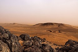
Richat Structure ISS030-E-12516
In this type of geologic structure, rocks exposed in the center of the “bullseye” are older than rocks forming the outer rings. This structure measures 45 kilometers (28 miles) across and is made up of igneous and sedimentary rocks. There are several faults visible (lower left) where strata that were once continuous have been shifted apart.
Most of Mauritania lies within the Sahara Desert, where dry climate conditions and periodic droughts create difficult living conditions. Approximately 3.7 million people live in Mauritania, though much of the population lives along its Atlantic coastline, about 500 kilometers (300 miles) from the Richat Structure.
Astronaut photograph ISS030-E-12516 was acquired on December 17, 2011, with a Nikon D2Xs digital camera using a 400 millimeter lens and is provided by the ISS Crew Earth Observations Facility and the Earth Science and Remote Sensing Unit, Johnson Space Center. The image was taken by a member of the Expedition 30 crew. The image has been cropped and enhanced to improve contrast, and lens artifacts have been removed. The International Space Station Program supports the laboratory as part of the ISS National Lab to help astronauts take pictures of Earth that will be of the greatest value to scientists and the public, and to make those images freely available on the Internet. Additional images taken by astronauts and cosmonauts can be viewed at the NASA/JSC Gateway to Astronaut Photography of Earth. Caption by Andrea Meado, Jacobs Technology, JETS Contract at NASA-JSC.Relevantní obrázky
Relevantní články
AtlantidaAtlantida či Atlantis je legendární kontinent, na kterém měla sídlit vysoce vyvinutá civilizace, kterou zničila mohutná přírodní katastrofa přibližně v roce 9600 př. n. l.. Přestože existence tohoto kontinentu nebyla nikdy přesvědčivě potvrzena, vedou se dodnes debaty o její existenci a možné poloze. Jediným zdrojem informací jsou Platónovy spisy Timaios a Kritias, v nichž popisuje atlantskou kulturu, státní zřízení a polohu; měla ležet někde za Herkulovými sloupy. .. pokračovat ve čtení
Oko SaharyOko Sahary je rozlehlá kruhová struktura v Mauretánii, dobře patrná při pohledu z vesmíru, rozkládající se v saharské poušti na hranici regionů Adrar a Tiris Zemmour nedaleko města Ouadane. Ríšat má průměr přibližně 50 km a skládá se z několika soustředných kruhů. Nejedná se o impaktní kráter. Podle výzkumů se jedná o geologický dóm. Vedou se spory, jak celá struktura vznikla. Objevila se i okrajová teorie, že Oko Sahary je ve skutečnosti pozůstatkem kdysi zničené bájné Atlantidy.[nenalezeno v uvedeném zdroji] .. pokračovat ve čtení


