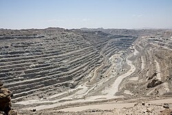
Rossing mine and vicinity 2013
Roessing’s 400-meter (1,300-foot) deep pit and a large processing facility north of it are the dominant features in the bottom image. The pit taps into layers of metasedimentary rock that contain intrusions of a type of coarse-grained igneous rock called pegmatite. Pegmatite often contains rare minerals and forms when magma slowly cools and hardens beneath the surface.
The mine sustains the small satellite town (population 7,600) of Arandis, which is visible near the top of the image. Roads and rail connect Arandis to Swakopmond, and there is a small airport south of Arandis. The dried channel of the Khan River is visible near the bottom of the image. While the surrounding landscape is largely devoid of vegetation, groundwater beneath the channel sustains some shrubs, trees, and grasses. The patches of green within and around the river channel in the top image are vegetation.
Some Namibians and environmental groups have raised concerns that water samples from the Khan River channel showed elevated uranium levels. Uranium carried in wastewater from the mine may be reaching groundwater and increasing uranium levels near the river. However, a study led by Michael Schubert, a scientist from the Helmholtz Center for Environmental Research, found that uranium also occurs naturally in the channel sediments. His team found no evidence that water contaminated by the mine had seeped into the groundwater.| This file is in the public domain in the United States because it was solely created by NASA. NASA copyright policy states that "NASA material is not protected by copyright unless noted". (See Template:PD-USGov, NASA copyright policy page or JPL Image Use Policy.) |  | |
 |
Warnings:
|
Relevantní obrázky
Relevantní články
Důl RössingDůl Rössing v Namibii je nejstarší a zároveň jeden z největších povrchových dolů na těžbu uranu na světě. Nachází se v Namibské poušti v regionu Erongo. Od přístavního města Swakopmundu je vzdálen zhruba 53 km km vzdušnou čarou směrem na severovýchod do vnitrozemí. Od hranic Národního parku Dorob na západě důl dělí zhruba 14 km, od hranic Národního parku Namib-Naukluft na jihu je vzdálen necelé 3 km a od koryta řeky Khan Rivier sotva 2 km vzdušnou čarou. .. pokračovat ve čtení


