TC Floyd 22 mar 2006 0235Z
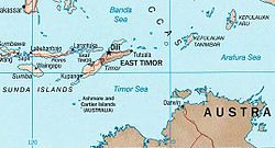
Tropical Cyclone Floyd formed northwest of Australia in the Timor Sea on March 21, 2006. The cyclone gained power gradually and was heading west into the Indian Ocean. It was not predicted to travel over any large landmasses, though it may pose a threat to Christmas Island well off the Western Australia coast in the Indian Ocean.
When the Moderate Resolution Imaging Spectroradiometer (MODIS) on the Terra satellite observed the storm at 11:55 a.m. Australian Western Daylight Saving time (02:35 UTC) on March 22, 2006, Tropical Cyclone Floyd was continuing to slowly build power and size. When MODIS made this observation, the storm had peak winds of around 120 kilometers per hour (75 miles per hour), and forecasts at the time called for it to continue to gather strength for at least several days, with predicted peak winds of 170 kilometers per hour (105 mph), according to the University of Hawaii’s Tropical Storm Information Center.| This file is in the public domain in the United States because it was solely created by NASA. NASA copyright policy states that "NASA material is not protected by copyright unless noted". (See Template:PD-USGov, NASA copyright policy page or JPL Image Use Policy.) |  | |
 |
Warnings:
|
Relevantní obrázky
Relevantní články
Timorské mořeTimorské moře je moře ohraničené na severu ostrovem Timor, na východě Arafurským mořem, na jihu Austrálií a na západě Indickým oceánem. Rozkládá se na ploše asi 610 000 km² a dosahuje hloubky 3200 m. Nachází se zde značné zásoby ropy a zemního plynu. .. pokračovat ve čtení


