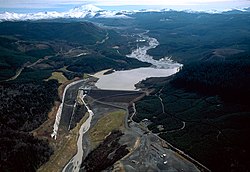
Toutle River in flood
Autor:
Bob Heims, U.S. Army Corps of Engineers
Shortlink:
Zdroj:
Formát:
1500 x 991 Pixel (1193705 Bytes)
Popis:
The mouth of the Toutle River in flood near Castle Rock, Washington. The Interstate-5 bridge is in the background. The photo was taken prior to the 1980 eruption of Mt. St. Helens.
Komentář k Licence:
This image or file is a work of a U.S. Army Corps of Engineers soldier or employee, taken or made as part of that person's official duties. As a work of the U.S. federal government, the image is in the public domain.
Licence:
Public domain
Credit:
U.S. Army Corps of Engineers Digital Visual Library
Image page
Image description page
Digital Visual Library home page
Image page
Image description page
Digital Visual Library home page
Relevantní obrázky
Relevantní články
Toutle (řeka)Toutle je řeka ve státu Washington, v severozápadní části USA. Délka toku činí 27,7 km a povodí zaujímá plochu 1 320 km². Orientuje se převážně západním směrem a je levostranným přítokem řeky Cowlitz. .. pokračovat ve čtení


