Volcanoes of Western Isabela
Autor:
NASA (Space Shuttle Endeavour)
Shortlink:
Zdroj:
Formát:
631 x 480 Pixel (101716 Bytes)
Popis:
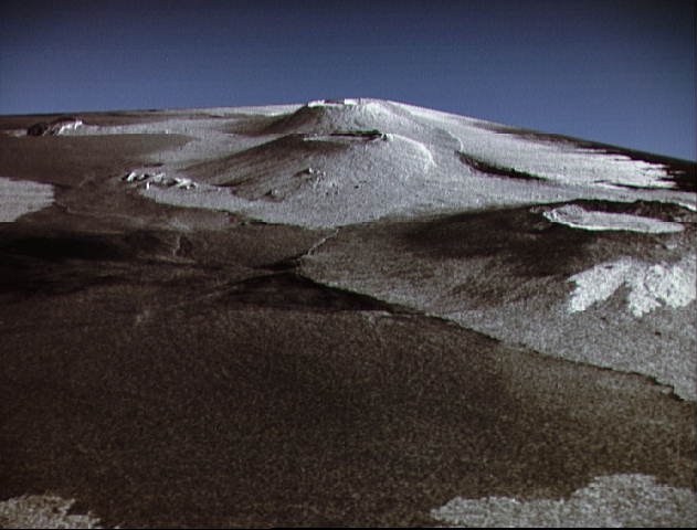
This is a three dimensional perspective view of Isla Isabela in the western Galapagos Islands. It was taken by the L-band radar in HH polarization from the Spaceborne Imaging Radar-C/X-Band Synthetic Aperature Radar on the 40th orbit of the Shuttle Endeavour. This view was constructed by overlaying a SIR-C radar image on a U.S. Geological Survey digital elevation map. The image is centered at about .5 degrees south latitude and 91 degrees West longitude and covers an area of 75 km by 60 km. This SIR-C/X-SAR image of Alcedo and Sierra Negra volcanoes shows the rougher lava flows as bright features, while ash deposits and smooth Pahoehoe lava flows dark. The Jet Propulsion Laboratory alternative photo number is P-43938.
Licence:
Public domain
Credit:
Sdílet obrázek:


Relevantní obrázky


Relevantní články
Darwin (sopka)Darwin, pojmenovaný po britském přírodovědci Charlesi Darwinovi, je v současnosti neaktivní štítová sopka nacházející se v severní části ostrova Isabela, který patří do souostroví Galapágy. Sopka je ukončena kalderou s průměrem 5 km, jejíž dno je pokryto mladými lávovými proudy. Další mladě vypadající lávové proudy a dvě tufové kupy se nacházejí na svazích sopky. Na západní a východní straně sahají proudy až k pobřeží. Erupce nebyly nikdy přímo pozorovány, jejich stáří je odvozen na základě analýz uvedených lávových proudů. .. pokračovat ve čtení