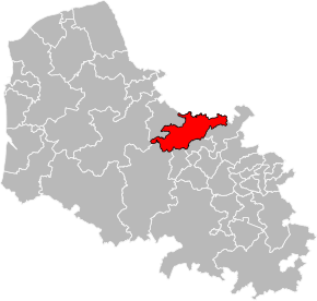
Kanton Lillers
| Kanton Lillers | |
|---|---|
| Geografie | |
| Hlavní město | Lillers |
| Souřadnice | 50°33′49″ s. š., 2°28′55″ v. d. |
| Rozloha | 180,84 km² |
| Obyvatelstvo | |
| Počet obyvatel | 39 415 (2015) |
| Hustota zalidnění | 218 obyv./km² |
| Správa regionu | |
| Stát | |
| Region | Hauts-de-France |
| Departement | Pas-de-Calais |
| Arrondissement | Béthune |
| Druh celku | Kanton |
| Podřízené celky | Obce (počet: 22) |
| Vznik | 2015 |
| Některá data mohou pocházet z datové položky. | |
Kanton Lillers (francouzsky Canton de Lillers) je francouzský kanton v departementu Pas-de-Calais v regionu Hauts-de-France. Tvoří ho 22 obcí. Před reformou kantonů 2014 ho tvořilo devět obcí.
Obce kantonu
od roku 2015:
- Allouagne
- Ames
- Amettes
- Auchy-au-Bois
- Bourecq
- Burbure
- Busnes
- Calonne-sur-la-Lys
- Ecquedecques
- Ferfay
- Gonnehem
- Ham-en-Artois
- Lespesses
- Lestrem
- Lières
- Lillers
- Mont-Bernanchon
- Norrent-Fontes
- Robecq
- Saint-Floris
- Saint-Venant
- Westrehem
před rokem 2015:
- Busnes
- Calonne-sur-la-Lys
- Gonnehem
- Guarbecque
- Lillers
- Mont-Bernanchon
- Robecq
- Saint-Floris
- Saint-Venant
Média použitá na této stránce
Autor: Pymouss, Licence: CC BY-SA 4.0
Carte de localisation du canton de Lillers dans le département du Pas-de-Calais, redécoupage de 2014.


