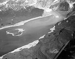
Evidence of 1958 Lituya Bay tsunami still clearly visible in 2010
Autor:
Shortlink:
Zdroj:
Formát:
4752 x 3168 Pixel (10315744 Bytes)
Popis:
Looking north at the far eastern end of Lituya Bay. Lituya Glacier to right and ridge to left showing clear difference between old and new vegetation where 1958 tsunami stripped vegetation to a height of 1700 feet. Rock face that caused tsunami is out of frame to the right.
Licence:
Credit:
Taken from sailboat Tokimata visiting Lituya Bay, August 2010.
Relevantní obrázky
Relevantní články
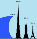
Lituya BayLituya Bay je fjord nacházející se na pobřeží Tichého oceánu v jihozápadní části Aljašky v USA. Na délku měří 14,5 km a na šířku 3,2 km. V roce 1958 v něm kvůli velkému sesuvu hornin vznikla nejvyšší zaznamenaná vlna tsunami, která dosáhla výšky 524 m. .. pokračovat ve čtení


