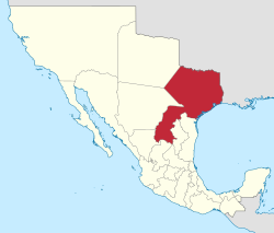
Map of the State of Coahuila and Texas
Autor:
Shortlink:
Zdroj:
Formát:
4122 x 3436 Pixel (11608278 Bytes)
Popis:
Philadelphia engraver, printer, map publisher, and instrument maker William Hooker's Map of Coahuila and Texas first appeared in an 1833 promotional book on Texas by Mary Austin Holley (1784-1846), a first cousin of the famous Texas colonizer Stephen F. Austin. Holley and her first publisher, Armstrong & Plaskitt of Baltimore substituted Hooker's map when Henry S. Tanner, the publisher of Stephen F. Austin's large map of Texas, refused to allow the latter to be used in the book. Both the 1836 map and book have some significant updates from the earlier map and book. Like the map by Hooker that appeared in A Visit to Texas, published by Goodrich & Wiley in New York in 1834, the 1836 map contains all the details of the earlier 1833 version but indirectly also refers to empresarios John McMullen and James McGloin, James Power, John Cameron, other new details such as "Herds of Buffalo" and "Droves of Wild Cattle & Horses" (phrases copied directly from the Austin-Tanner map) and peaks in the west, "Presidio de Rio Grand" [sic], additional towns across the Rio Grande in Chihuahua and Coahuila, the Cross Timbers, Fort Tenoxtitlan, Comanche Indian lands in the west, Cherokee, Creek, and Choctaw Indian lands north of the Red River. In addition, this 1836 map adds other details, such as references to the grants of Juan Antonio Padilla and Thomas Jefferson Chambers in the panhandle (awarded in 1830), and those of John Charles Beale and Dr. James Grant in the west. Further, the map includes the towns of Bastrop, Gonzales, Cole's Settlement (Independence), Montezuma, Orizumba, Columbia, Bell's Landing, and De Leon's colony. The words "now Filisola" are stamped in northeast Texas next to Thorn's Grant – referring to an empresario land grant awarded in 1831 to Italian-born Mexican Army General Vicente Filisola (1789-1850). Handwritten additions in ink on the map are references to Benjamin Milam's grant in the far northeast and the towns of Washington (on the Brazos), Corpus Christi, and [San] Augustine.
Licence:
Public domain
Relevantní obrázky
Relevantní články
Coahuila y TejasCoahuila y Tejas byl jeden se zakládajících členů novozaloženého státu Spojené státy mexické na základě Ústavy z roku 1824. .. pokračovat ve čtení


