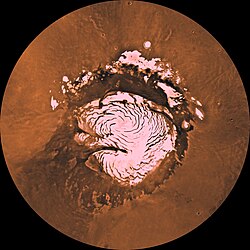
MRO image of Mars North Pole
Autor:
product of NASA.
Shortlink:
Zdroj:
Formát:
2000 x 5060 Pixel (9107318 Bytes)
Popis:
This false-color subframe shows the north polar layered deposits at top and darker materials at bottom exposed in a scarp at the head of Chasma Boreale, a large canyon eroded into the layered deposits. The polar layered deposits appear red because of dust mixed within them, but are ice-rich as indicated by previous observations. The water ice in the layered deposits is probably responsible for the pattern of fractures seen near the top of the scarp. The darker material below the layered deposits may have been deposited as sand dunes, as indicated by the cross-bedding (truncation of curved lines) seen near the middle of the scarp. It appears that brighter, ice-rich layers were deposited between the dark dunes in places.
Image PSP_001334_2645 was taken by the High Resolution Imaging Science Experiment (HiRISE) camera onboard the Mars Reconnaissance Orbiter spacecraft on November 8, 2006. The complete image is centered at 84.4 degrees latitude, 343.5 degrees East longitude. The range to the target site was 317.4 km (198.4 miles). At this distance the image scale ranges from 31.8 cm/pixel (with 1 x 1 binning) to 63.5 cm/pixel (with 2 x 2 binning). The image shown here [below] has been map-projected to 25 cm/pixel. The image was taken at a local Mars time of 1:38 PM and the scene is illuminated from the west with a solar incidence angle of 67 degrees, thus the sun was about 23 degrees above the horizon. At a solar longitude of 132.3 degrees, the season on Mars is Northern Summer.
Licence:
Public domain
Relevantní obrázky
Relevantní články
Planum BoreumPlanum Boreum je planina severního polárního kruhu na Marsu. Rozkládá se směrem na sever od souřadnice 80 ° S a její střed se nachází na souřadnicích 88.0 ° S 15.0 ° V. Obklopuje ji vysokohorská rovná polární planina s členitými nížinami pojmenována Vastitas Borealis, která se táhne přibližně 1500 km jižním směrem a je dominantou severní polokoule. V roce 1999 Hubbleův vesmírný teleskop zachytil cyklonu v tomto regionu. Průměr této bouře byl přibližně 1750 km s okem bouře 320 km. .. pokračovat ve čtení


