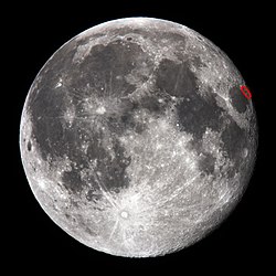
Mare Anguis
Autor:
NASA
Shortlink:
Zdroj:
Formát:
350 x 382 Pixel (19250 Bytes)
Popis:
en:Mare Anguis is in the middle of the picture. It is located on the near side of the moon (the side facing the Earth), and is about 150 miles in diameter. Located within the Crisium basin, Mare Anguis is a part of the Nectarian System, meaning that it was formed during the Nectarian time period (according to Wilhelms, 1987 (Plate 9A) - Upper Imbrian epoch). Like most maria, the surface of Mare Anguis is dark, indicating that it has been filled with volcanic basalt. The crater at the left center is Eimmart, at the northwestern tip of Mare Anguis. The dark patch in the lower left corner is the northeastern edge of Mare Crisium.
Licence:
Public domain
Relevantní obrázky
Relevantní články
Mare AnguisMare Anguis je malé měsíční moře nepravidelného tvaru s plochou přibližně 10 000 km² rozkládající se na severovýchodním okraji Mare Crisium na přivrácené straně Měsíce. Dominantu zde tvoří výrazný kráter Eimmart se sítí satelitních kráterů. Povrch moře je tmavý, což indikuje, že moře bylo vyplněno vulkanickými bazalty. .. pokračovat ve čtení


