Sea Ice Imitates the Shoreline along the Kamchatka Peninsula
Autor:
MODIS Rapid Response Team
Formát:
1600 x 2100 Pixel (837724 Bytes)
Popis:
The resemblance between the sea ice and the coastline is most conspicuous around Kamchatskiy Poluostrov—a peninsula that extends eastward from the coast, curling toward the south like a knobby claw.
Ice fills the bay inside this peninsula, and the land and ice combined span roughly 85 kilometres north to south. South of this peninsula floats a formation of sea ice. A lobe of especially thick ice in this formation mimics the inlet south-west of Kamchatskiy Poluostrov. Much of the ice in this lobe is likely composed of layers of relatively thin ice that have rafted, or stacked, into thick layers. Adjacent to this northward-projecting lobe, the sea ice retreats to the south, imitating the overall shape of the peninsula. Immediately east of the peninsula, sea ice floats close to the coastline. North of the peninsula, another formation of sea ice traces the shape of the coast, separated from shore by open
water. The similarity between the eastern margin of the land and the western margin of the sea ice suggests that the ice formed along the shore and was later pushed away and slightly deformed by
winds. Down-slope winds can be powerful along shorelines, and many of the
volcanic peaks on the Kamchatka Peninsula, including
Shiveluch and Klyuchevskaya, provide high points from which such winds can descend. Besides being steady and strong, down-slope winds are also cold, and the frigid wind over the ocean surface has helped form fresh sea ice in areas where older ice was blown out to sea. Newly forming ice is most obvious south-west of Kamchatskiy Poluostrov and east of Klyuchevskaya Volcano.
Více informací o licenci na obrázek naleznete zde. Poslední aktualizace: Thu, 30 Jan 2025 13:57:51 GMT
Relevantní obrázky
Relevantní články
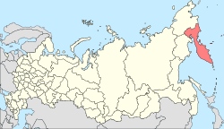
Kamčatka
Kamčatka je 1 250 km dlouhý poloostrov na ruském Dálném východě o rozloze 270 000 km². Na západě poloostrova se nachází Ochotské moře, na východě Tichý oceán. Podél poloostrova se táhne Kurilsko-kamčatský příkop s hloubkou přes 10 500 m.
.. pokračovat ve čtení
Mořský led
Mořský led je zmrzlá mořská voda. Vzhledem k tomu, led má menší hustotu než voda, plave na hladině oceánu. Mořský led pokrývá asi 7 % zemského povrchu a asi 12 % světových oceánů. Může být souvislý, takže se po něm dá chodit a jezdit, může jít i o drobné počáteční nebo naopak zbytkové kousky, pohybující se na hladině.
.. pokračovat ve čtení


