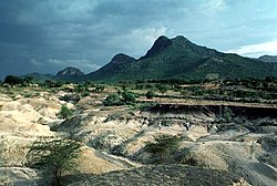
Tousside, Tibesti Mountains, Chad
Autor:
NASA (STS-52)
Shortlink:
Zdroj:
Formát:
5288 x 5248 Pixel (7985502 Bytes)
Popis:
Tousside, Tibesti Mountains, Chad
- The Tibesti Mountains in northwestern Chad consist of rugged volcanic peaks, many impressive craters, and hot springs. Near the center of the photograph is Tousside Peak, which rises more than 10 710 feet (3265 meters) above sea level, the westernmost volcano of this high mountain range. The peak is almost centered within the black shape that has tentacle-shaped lava flows extending down the western flank. The volcano’s base measures approximately 55 miles (90 kilometers) in diameter. The light brownish area surrounding the peak shows a distinctive radial drainage pattern that is quite common for stratovolcanoes as the terrain falls away from the main peak. The depression southeast of the volcano measures approximately 5 miles (8 kilometers) in diameter and 3300 feet (1000 meters) in depth. The white base is caused by an accumulation of carbonate salts, creating this soda lake of Tibesti. With the exception of small vents that emit gasses and a few hot springs that continue to deposit minerals at the surface of the crater floor, little volcanic activity presently occurs in this region.
Image number STS052-73-14
Licence:
Public domain
Relevantní obrázky
Relevantní články
Tarso ToussidéTarso Toussidé je 3265 metrů vysoký stratovulkán severu Čadu. Tvoří rozsáhlý sopečný masiv na západním okraji pohoří Tibesti a jeho rozloha je přibližně 6 000 km². .. pokračovat ve čtení
Seznam sopek v AfriceToto je seznam sopek v Africe. .. pokračovat ve čtení


