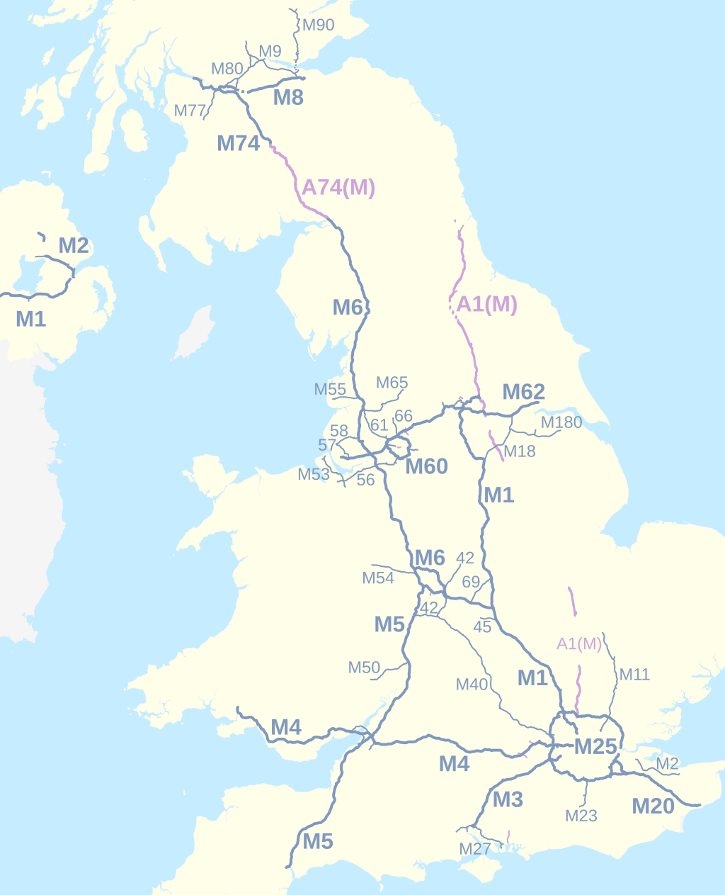
UK motorways map 2016
Nilfanion and Dr Greg. © OpenStreetMap contributors. Contains Ordnance Survey data © Crown copyright and database right 2010., CC BY-SA 4.0
Autor:
- A38 UK road map.svg: Nilfanion, created using Ordnance Survey data
- Stirling UK location map.svg: Nilfanion, created using Ordnance Survey data
- Fife UK location map.svg: Nilfanion, created using Ordnance Survey data
- Glasgow UK location map.svg: Nilfanion, created using Ordnance Survey data
- Scottish council areas 2011.svg: Nilfanion, created using Ordnance Survey data
- North Yorkshire UK location map.svg: Nilfanion, created using Ordnance Survey data
- OpenStreetMap: OpenStreetMap contributors
- derivative work: Dr Greg
Shortlink:
Zdroj:
Formát:
1038 x 1279 Pixel (525375 Bytes)
Popis:
Map of the motorways of the United Kingdom in 2016. The shortest motorways are not labelled. Motorways in Northern Ireland are numbered independently from motorways in Great Britain.
Equirectangular map projection on WGS 84 datum.
- Key
M-designated motorway
under construction
Upgraded A-road designation
under reconstruction
Licence:
Credit:
Tento soubor byl odvozen z:
-
 A38 UK road map.svg
-
 Stirling UK location map.svg
-
 Fife UK location map.svg
-
 Glasgow UK location map.svg
-
 Scottish council areas 2011.svg
-
 North Yorkshire UK location map.svg
- OpenStreetMap for Northern Ireland motorways: http://www.openstreetmap.org/#map=8/54.687/-5.606 2016-02-21
Relevantní obrázky


Nilfanion and Dr Greg. © OpenStreetMap contributors. Contains Ordnance Survey data © Crown copyright and database right 2010., CC BY-SA 4.0

(c) Mat Fascione, CC BY-SA 2.0

(c) HENRY CLARK, CC BY-SA 2.0

Nilfanion and Dr Greg. © OpenStreetMap contributors. Contains Ordnance Survey data © Crown copyright and database right 2010., CC BY-SA 4.0

Nilfanion and Dr Greg. © OpenStreetMap contributors. Contains Ordnance Survey data © Crown copyright and database right 2010., CC BY-SA 4.0

Nilfanion and Dr Greg. © OpenStreetMap contributors. Contains Ordnance Survey data © Crown copyright and database right 2010., CC BY-SA 4.0

Nilfanion and Dr Greg. © OpenStreetMap contributors. Contains Ordnance Survey data © Crown copyright and database right 2010., CC BY-SA 4.0

Nilfanion and Dr Greg. © OpenStreetMap contributors. Contains Ordnance Survey data © Crown copyright and database right 2010., CC BY-SA 4.0

Nilfanion and Dr Greg. © OpenStreetMap contributors. Contains Ordnance Survey data © Crown copyright and database right 2010., CC BY-SA 4.0

Nilfanion and Dr Greg. © OpenStreetMap contributors. Contains Ordnance Survey data © Crown copyright and database right 2010., CC BY-SA 4.0

Nilfanion and Dr Greg. © OpenStreetMap contributors. Contains Ordnance Survey data © Crown copyright and database right 2010., CC BY-SA 4.0

Nilfanion and Dr Greg. © OpenStreetMap contributors. Contains Ordnance Survey data © Crown copyright and database right 2010., CC BY-SA 4.0

Nilfanion and Dr Greg. © OpenStreetMap contributors. Contains Ordnance Survey data © Crown copyright and database right 2010., CC BY-SA 4.0

Nilfanion and Dr Greg. © OpenStreetMap contributors. Contains Ordnance Survey data © Crown copyright and database right 2010., CC BY-SA 4.0

Nilfanion and Dr Greg. © OpenStreetMap contributors. Contains Ordnance Survey data © Crown copyright and database right 2010., CC BY-SA 4.0

Nilfanion and Dr Greg. © OpenStreetMap contributors. Contains Ordnance Survey data © Crown copyright and database right 2010., CC BY-SA 4.0

Nilfanion and Dr Greg. © OpenStreetMap contributors. Contains Ordnance Survey data © Crown copyright and database right 2010., CC BY-SA 4.0

Nilfanion and Dr Greg. © OpenStreetMap contributors. Contains Ordnance Survey data © Crown copyright and database right 2010., CC BY-SA 4.0

Nilfanion and Dr Greg. © OpenStreetMap contributors. Contains Ordnance Survey data © Crown copyright and database right 2010., CC BY-SA 4.0

Nilfanion and Dr Greg. © OpenStreetMap contributors. Contains Ordnance Survey data © Crown copyright and database right 2010., CC BY-SA 4.0

Nilfanion and Dr Greg. © OpenStreetMap contributors. Contains Ordnance Survey data © Crown copyright and database right 2010., CC BY-SA 4.0

Nilfanion and Dr Greg. © OpenStreetMap contributors. Contains Ordnance Survey data © Crown copyright and database right 2010., CC BY-SA 4.0

Nilfanion and Dr Greg. © OpenStreetMap contributors. Contains Ordnance Survey data © Crown copyright and database right 2010., CC BY-SA 4.0

Nilfanion and Dr Greg. © OpenStreetMap contributors. Contains Ordnance Survey data © Crown copyright and database right 2010., CC BY-SA 4.0

Nilfanion and Dr Greg. © OpenStreetMap contributors. Contains Ordnance Survey data © Crown copyright and database right 2010., CC BY-SA 4.0

Nilfanion and Dr Greg. © OpenStreetMap contributors. Contains Ordnance Survey data © Crown copyright and database right 2010., CC BY-SA 4.0

Nilfanion and Dr Greg. © OpenStreetMap contributors. Contains Ordnance Survey data © Crown copyright and database right 2010., CC BY-SA 4.0

Nilfanion and Dr Greg. © OpenStreetMap contributors. Contains Ordnance Survey data © Crown copyright and database right 2010., CC BY-SA 4.0

Nilfanion and Dr Greg. © OpenStreetMap contributors. Contains Ordnance Survey data © Crown copyright and database right 2010., CC BY-SA 4.0

Nilfanion and Dr Greg. © OpenStreetMap contributors. Contains Ordnance Survey data © Crown copyright and database right 2010., CC BY-SA 4.0

Nilfanion and Dr Greg. © OpenStreetMap contributors. Contains Ordnance Survey data © Crown copyright and database right 2010., CC BY-SA 4.0

Nilfanion and Dr Greg. © OpenStreetMap contributors. Contains Ordnance Survey data © Crown copyright and database right 2010., CC BY-SA 4.0

Nilfanion and Dr Greg. © OpenStreetMap contributors. Contains Ordnance Survey data © Crown copyright and database right 2010., CC BY-SA 4.0

Nilfanion and Dr Greg. © OpenStreetMap contributors. Contains Ordnance Survey data © Crown copyright and database right 2010., CC BY-SA 4.0

Nilfanion and Dr Greg. © OpenStreetMap contributors. Contains Ordnance Survey data © Crown copyright and database right 2010., CC BY-SA 4.0

(c) Mat Fascione, CC BY-SA 2.0


(c) Paul McIlroy, CC BY-SA 2.0


Relevantní články
Dálnice ve Spojeném královstvíCelková délka dálnic ve Spojeném království činí 3 218 km. Nejvyšší povolená rychlost na dálnicích je pro osobní automobily 112 km/h. Většina dálnic není zpoplatněna, zpoplatněny jsou pouze některé úseky, mosty, tunely, či vjezdy do velkých měst, kde funguje mýtný systém. .. pokračovat ve čtení
