Zagros 1992


Autor:
NASA
Formát:
639 x 511 Pixel (108258 Bytes)
Popis:
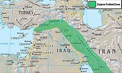
Zagros Mountains, Iran. Photo center point: 28.0° N, 54.0° E (near Banaruyeh). NASA Space Shuttle photo STS047-151-35.JPG. One of the most beautifully folded mountain ranges in the world, the southern Zagros Mountains of western Iran can be seen in this south-southwest looking low oblique view. Pushed up by the collision of crustal plates, the Zagros Mountains were buckled into high folds, or anticlines, and depressions, or synclines. Extending from northwest to southeast is a broad zone of long parallel lines of enormous hogback ridges and deep intervening valleys (right center to upper center of the image). There are numerous salt marshes in many of the valleys, such as Lake Bakhtegan, visible in the lower left portion of the image. Iran's major oil fields lie along the western foothills, where salt domes have trapped oil. The Persian Gulf is visible in the upper right portion of the image.
Komentář k Licence:
Public domain This file is in the public domain in the United States because it was solely created by NASA. NASA copyright policy states that "NASA material is not protected by copyright unless noted". (See Template:PD-USGov, NASA copyright policy page or JPL Image Use Policy.)
Warnings:
Licence:
Public domain
Credit:
NASA
Sdílet obrázek:
Facebook   Twitter   Pinterest   WhatsApp   Telegram   E-Mail
Více informací o licenci na obrázek naleznete zde. Poslední aktualizace: Wed, 24 Jan 2024 09:35:39 GMT

Relevantní obrázky


Relevantní články

Íránská vysočina

Íránská vysočina je hornatá oblast v jihozápadní Asii, která je tvořena velkou bezodtokovou náhorní plošinou s průměrnou výškou 1200 m n. m. Na západě je ohraničena řekami Eufrat a Tigris, na východě pohořím Hindúkuš a Sulajmánským pohořím. Severní hranici tvoří pohoří Elborz a Kopet Dag, jižní hranici tvoří Perský záliv a Arabské moře. .. pokračovat ve čtení

Zagros

Zagros je rozsáhlé pohoří v západní Asii. Táhne se v délce 1 500 km ze západního Íránu a severního Iráku podél hranic obou zemí až k severnímu pobřeží Perského zálivu. Má šířku 150 až 300 km. Jeho nejvýchodnější část zasahuje až k Hormuzskému průlivu. Nejvyššími vrcholy pohoří jsou Zard Kuh (4 548 m) a Dena (4 359 m). Zagros je největším pohořím Íránu. .. pokračovat ve čtení